


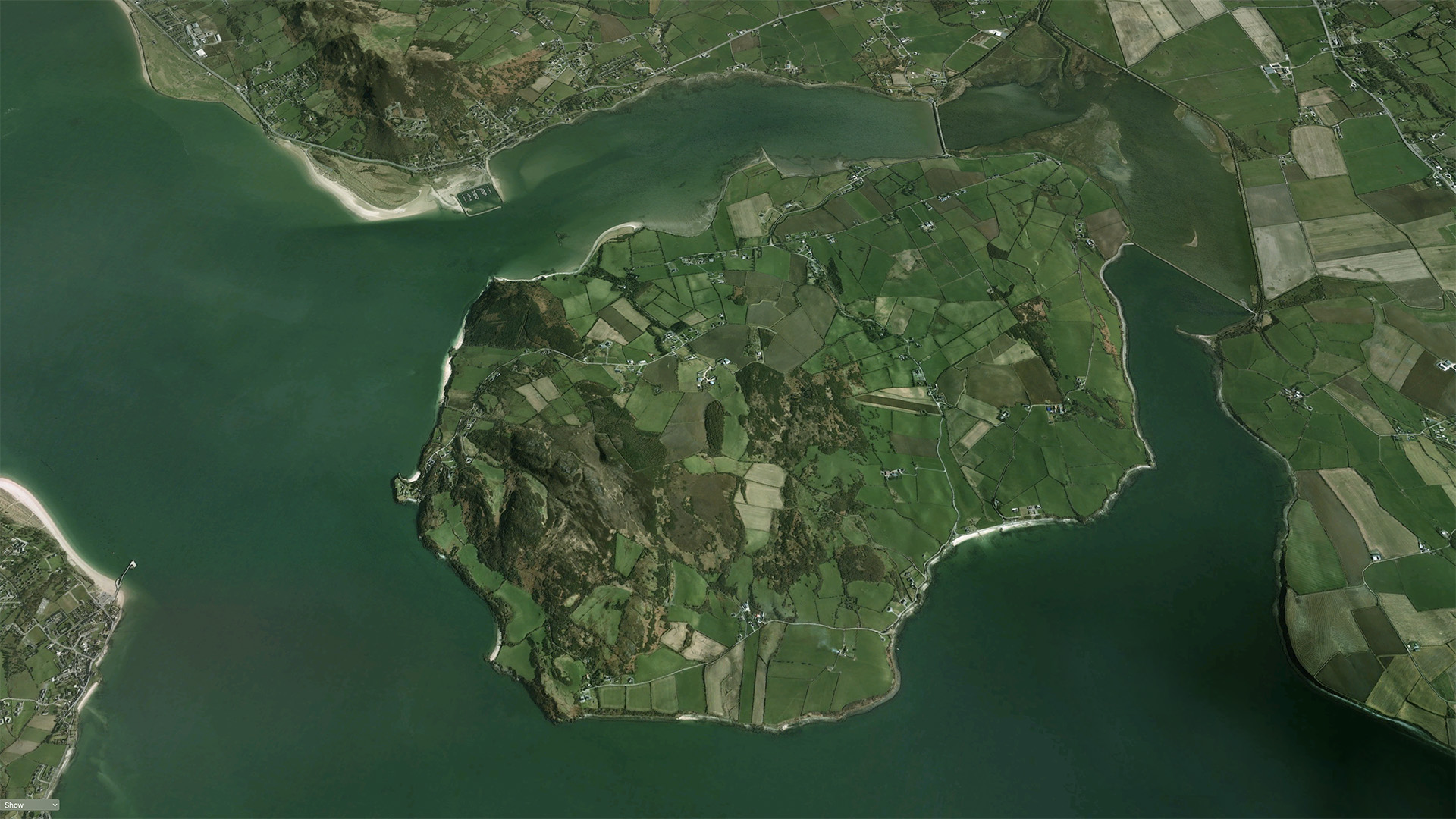
Situated in the far north-west of Ireland, the coastline of County Donegal is a zig-zag of headlands and inlets, the deepest of which is Lough Swilly (Irish: Loch Súilí, meaning ‘Lake of Shadows’), a glacial fjord, formed during the last ice-age, 35,000-11,500 BCE.
At the neck of the Swilly, 30 kms from the waves of the Atlantic, lies the island of Inch, its original Irish name An Inis na n-Osirí, the Island of the Oysters. Inch is 13 km2, with some of the most fertile soil in Donegal.
These rich acres contain Neolithic standing stones, bronze-age graves, iron-age forts, oyster-shell middens, an early-Christian site, a medieval castle, three churches, a Masonic lodge, 18th century industrial archaeology, a Napoleonic-era fort, and the traces of a fishing industry that once sent Lough Swilly herring to Trinidad and Russia.
Please Note: The historic sites and buildings featured in the timeline below are in private ownership, and are not accessible to the general public. The CINE Project was granted special access to record and archive their history. If you intend to visit Inch, please respect the privacy of the islanders and the unique heritage of the island.
Click this link for Geohive maps of Inch.
Scroll down the timeline, and click on the images to explore the fascinating wealth of the island’s history.
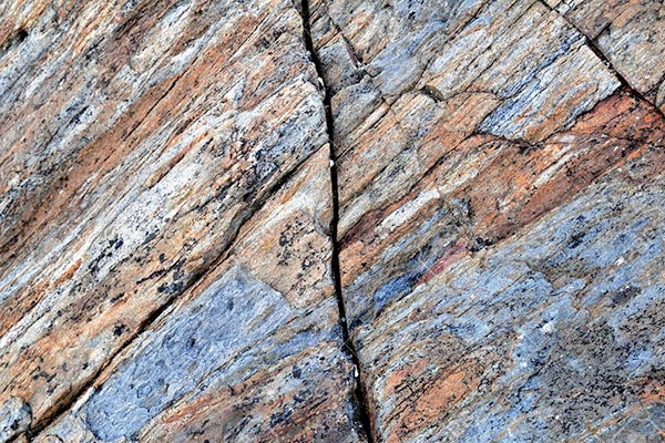
The geology of Inch comprises mostly of metamorphic rocks, formed under huge pressures and temperatures.
The rocks of Inch are of two main types in three distinct bands running south west to north east. To the north and south of the island there are Neoproterozoic Southern Highland Groups (Pelitic & psammitic schist, phyllite & marble) 1000 million to 541 million years old. The central swathe is part of the Neoproterozoic Argyll Group (Psammitic & pelitic schist, marble, amphibolite, diamictite), the southern boundary being the Belshade fault, which runs from just north of O’Doherty’s Castle, to the road along Inch Bank. Further reading is available from these links.
Click image for more details
Throughout the Last Glacial Maximum (ca. 26,000 - 19,000 years ago), Ireland was an arctic wasteland, or tundra. This period's effects on Ireland are referred to as Midland General Glaciation. The ice-sheet carved the bedrock of Ireland, before the Bølling-Allerød period (ca.17,500 - 12,000 years ago) when the ice melted, resulting in Post-Glacial Rebound - the rise of land masses after the lifting of the huge weight of ice. The land of Donegal rose by over 7 metres, leaving a landscape we recognise today.
Below is a further extract from Harry Percival Swan’s ‘Romantic Inishowen’. Although published in 1947, and succeeded by newer works on geology and history, the book belongs as much to the heritage of Inch and Inishowen, as any more recent publications. Enthusiasts like Swan and Mabel Colhoun are an integral part of Inishowen’s history.
"We inherit the ages lying
In the buried past of the earth."
- Arthur O'Shaughnessy
During the Ice Age, Inishowen, like the rest of North-West Europe, was completely buried beneath an ice-sheet. The ice, probably about 3,000 feet thick, swept over Inishowen from the Donegal Hills, where lay its source, and proceeded across hill and dale parallel roughly with the Foyle and Swilly. On the north of the peninsula, it flowed off the coast and gave rise doubtless to icebergs in the Atlantic.
The ice, shod with boulders and other debris, scratched the rocks over which it passed and scored them in the direction of its own flow. It also moulded the hills into the beautifully rounded forms which are everywhere apparent.
Good examples of these scratches are readily seen on Inch Top, Inch Island.
The ice also brought with it materials from the west, including the rounded granite boulders, derived from the Barnesmore Mountains in County Donegal, which careful search fill find in all parts of the peninsula. It laid down the sands and gravels and clays which floor the valleys and lower parts of the country.
Among the glacial erratics is “Mell-yore”, a block weighing many tons at Cashel Hill above the village of Burnfoot.
With the passing away of glacial conditions, the ice gradually diminished in thickness. It was no longer able to surmount the highest peaks, such as Slieve Snacht and Bulbin. These, therefore, emerged above the ice-surfaces, and the once-continuous ice broke up into powerful glaciers which streamed from the south-west along Lough Swilly and Lough Foyle, and along the Glentogher and Mintiaghs valleys.
These glaciers shrank southwards. They withdrew from the Glentogther and Mintiaghs valleys, and only glaciers in Lough Foyle and Lough Swilly remained. The Swilly Glacier ponded a lake in the broad valley of the Owenkillew River, north-east of Buncrana. The lake overflowed by the valley which begins just north of the Mintiaghs Lough and falls northward into the valley of the Clonmany River.
After the retiral of the main mass of Donegal ice, an occasional corrie glacier nestled in a hollow where the ice and snow were protected from the sun. One such small glacier lingered on the west side of the Gap of Mamore, where its frontal moraine of large stones is clearly to be seen.
Subsequent to the release of Inishowen from its icy cover, the peninsula has risen about 20 feet. The raised sea-beach which marks the ancient shore and is no longer washed by the waves may now be seen as flat shelves, now in rock, now as gravel beach, at intervals along the Lough Foyle shore (as south-east of Muff), flooring the depression between Culdaff and Carndonagh, extending west of the road from Carndonagh to Malin, and north of the Carndonagh-Ballyliffin Road.
The great shingle accumulation, on the southern side of Malin Head, which contains pebbles and boulders of all kinds of rock brought by the ice from the south-west, is doubtless such a raised beach, but probably also contains much storm material, hurled up in the past by great waves on this exposed coast.
The most magnificent example of this raised sea-floor, however, is that which forms Magilligan Strand, which stretches out into Lough Foyle opposite Greencastle. Its flatness provided an admirable baseline for the primary triangulation of the British Isles by the Ordinance Survey in 1827.
At this period when the sea covered the raised beaches the sea entered the depression which runs from Londonderry to Fahan from either end, and the middle part which was probably not submerged was rendered marshy. Inishowen was at this time an island.
Professor J. Kaye Charlesworth, D.Sc.
DownloadsThe Holocene is the period which corresponds with the rapid proliferation, growth and impacts of the human species worldwide.
Taken from Romantic Inishowen by Harry Percival Swan
Published in 1947 by Hodges Figgis & Co., Ltd., Dawson Street, Dublin
"We, the heirs of all the ages,
In the foremost files of time."
- Tennyson
The question of chronology, on which I am asked to say a few words, is one of much difficulty. When we pass in time back to a period before the introduction of any form of writing, we are deprived of the powerful aid of datable documents.
The problem is not, however, hopeless, although the final establishment of a complete scheme has not yet been attained. It is best, in such a study, to proceed backwards from the known to the unknown, and to see what fixed points we have to give us a framework.
We pause at the date of the beginning of the Anglo-Norman occupation, the central year of which is 1172 A.D. This inaugurated the late mediaeval period of Irish Art; though possibly the foundation of the first Cistercian Monastery at Mellifont, Co. Louth (1142 A. D.) would be a better landmark.
The next stage is inaugurated by the beginning of Scandinavian aggression, in the 8th and 9th century. This made a complete revolution in the life, manners, morals and art of the country – much more complete than appears at first sight; and it certainly makes an epoch of great importance.
Perhaps we may name as our next date, the departure of the Colum Cille for Scotland in 563 A.D., which inaugurated the remarkable outburst of missionary activity among the ecclesiastics of Ireland during the 7th and 8th centuries. This period is sometimes called “The Golden Age” with, perhaps, undue optimism. But it was altogether to the benefit of the country that its emissaries came in contact with the architectural and other cultural attainments of the Continent and the Near East. Undoubtedly it was to these foreign connections that the development of mortared stone building, and of the Romanesque style in Ireland, was primarily due.
The arrival of St. Patrick as a missionary, 432 A.D., is the next point. He found the country predominantly pagan, though undoubtedly there were Christians in it before his time. He left it well on the way to becoming predominantly Christian.
We next come to the arrival of the Iron culture, which seems to be datable, to judge from the few relics which it has left, to late in the second La Tène period, say sometime shortly before 100 B.C. This is the time of the beginning of the sagas of Cuchulain and his contemporaries.
Before that, we are in the Bronze Age, beginning somewhere about 2000 B.C. It is specially marked by the erection of great “Megalithic” monuments – chambered tumuli such as Dowth horned cairns, and the so-called “dolmeni”, and at a later period stone circles.
In the early part of this period, the country’s wealth in gold and copper enabled it almost to command the markets of Northern Europe. This time of prosperity was brought to an end by the destructive invasion of the “Beaker People” somewhere about 1200 B.C., which, like the Scandinavians 2,000 years later, effected a complete revolution in the country’s life and culture. But the Scandinavians imported their arts. The “Cross of Cong”, for example, would never have come into existence, in the form in which we know it, had it not been for Scandinavian influence. The “Beaker People” brought nothing but a set-back into barbarism.
Earlier still, in the Neolithic and Mesolithic ages, the chronology becomes much less definite. The Larne flint workings have been assigned to dates as diverse as 4000 and 7000 B.C. That is the farthest back to which we can go at present; no certain evidence of a Palaeolithic Period in Ireland has ever come to light.
No correlation whatever can be established between these phases of civilisation or waves of migration, and the strange peoples, Fomorians, Partholonians, Nemidians, Fir Bold and the rest, of which the legendary histories tell us much. These belong to the dreamland of folklore and nowhere else. The stories about them may incorporate vague reminiscences of immigrations, but they are so completely overlaid with fable that they have no real value for the pure historian. They have an interest, but it lies elsewhere – in the history of religion, ritual, and culture, for which they provide the earliest material available in the non-classical literature of Europe.
3D renderings of stone age tools from Donegal County Museum’s Collection
The warming of the Bølling-Allerød period allowed for the rehabilitation of northern areas of Europe by roaming hunter-gatherers, searching for auroch, elk and reindeer, and supplementing their diet with fish and shellfish.
A collection of artefacts excavated at Eleven Ballyboes, Greencastle suggest evidence of human habitation on Inishowen dating back to 7,000 BCE.
The submerged area at Eleven Ballyboes lies just off the coast and is considered among the earliest to produce an abundance of objects created by the first hunter-gatherer inhabitants in Ireland, following the end of the ice age.
The artefacts, which include tools and weapons such as flint knifes have been carbon dated to the early Mesolithic period, and are now in the collection of the National Museum.
Kieran Westley from Ulster University authored a paper on the excavations.
Taken from Romantic Inishowen by Harry Percival Swan
Published in 1947 by Hodges Figgis & Co., Ltd., Dawson Street, Dublin
“In the glimmer of the dawn they stand the solemn silent witnesses of ancient days."
- Archaeological Journal
The bronze age in Ireland is taken to begin about 2000 B.C. Stone Age peoples lived in portion[s] of the country for almost 5,000 years before this, but the main part of this period does not concern us. In dealing with Inishowen we have to consider only the last portion of the Stone Age, known as the Neolithic (or New Stone Age) which precedes the beginning of the Bronze Age by a comparatively short interval and forms an important introduction to it.
Its importance lies in the fact that the Neolithic Period saw the beginning of the arts of agriculture and the keeping of domestic animals – arts on which all subsequent human progress is based. This new knowledge, from an ultimate origin in the Near and Middle East, spread to Ireland from the Mediterranean and Western Europe. Subsidiary arts which were introduced at this period were the making of pottery and of textiles. From the type of pottery distinctive of the Neolithic, archaeologists are able to identify the habitations and burial sites of this period. Pottery of this type is not known to have been found in Inishowen, but a class of tomb which had beginnings in Neolithic times is well represented; and though these tombs may date in large part from the Bronze Age, they give evidence of the earliest colonisation of the area.
These tombs, built of great stones and hence known as “megalithic” tombs, were usually intended for “collective burial”, that is they held the remains of several persons, acting probably as the family vaults of their builders. Generally, there now remain only very dilapidated structures – the cairn of stones which formerly protected them and some of the uprights and capstones that formed the chambers having, in the course of thousands of years, been robbed for building, for fence-making, road-metalling and other purposes. It is, therefore, frequently difficult to be sure of the types of tomb represented by the few stones that remain to us.
From the published accounts one can enumerate a total of about eighteen tombs in Inishowen, but because of lack of detail some of them are rather doubtful, and only about half the number are sufficiently well described and preserved to enable us to decide to which sub-classes they belong. From the information at our disposal it is possible to say that types of tombs well represented in other parts of the country have also examples in Inishowen.
The well-preserved tomb at Laraghirril (or Deen) is related to the “horned cairn” group. These monuments are so called because the front of the tomb is marked by a curved façade of uprights, through which the gallery containing the burial is approached. Horned cairns extend from Carlingford Lough, where a focus of the group points to their entry into Ireland, across central and southern Ulster and to Sligo in the West. The Laraghirril example – an outlier of the type – gives evidence that their builders lived also in Inishowen.
The tomb at Upper Gransha, near Buncrana, is a representative of another class – the wedge-shaped gallery graves generally known as Dolmens which, in different forms, are found very widely distributed in Ireland, and have connections further afield in France and South-Western Europe.
At Carnagh on Inch Island is an interesting monument, locally known as the “King’s Grave”, which may be part of a larger structure. Part of the cairn remains, and this as well as a growth of briars and bushes, obscures its features. It appears to consist of two parts – an imposing chamber, built of three uprights, two of them forming great front portals about 9 feet in height and, behind this, a smaller rectangular grave covered by a massive capstone. Megalithic tombs characterised by portal stones are well represented throughout Ireland. In the Carnaghan monument was found a pot of the type known as a “food vessel”, now in Derry Museum.
Food-vessels are so called because they are frequently found in graves with skeletons, and are thought to have contained an offering of food to help the departed on the journey to the next life. They are also used as urns to contain the cremated bones of the dead. Another food-vessel from Inishowen, also in Derry Museum, came from the townland of Craig. It was found in a grave of Bronze Age type – a rectangular stone cist, about 3 feet in length, and 2 feet wide, and with it a crouched skeleton lying on its side. From a burial mound at Glenagannon, near Carndonagh, came two other food-vessels, while other pottery vessels, vaguely described as “urns”, were found at Culoort, near Malin Head. We have no adequate description of these vessels but urns properly so called are bigger than the food-vessels already mentioned, and are the type of sepulchral pottery characteristic of the Late Bronze Age.
Another class of monument ascribed to the Bronze Age is the stone circle, and it is exemplified in Inishowen by one on Bocan Hill, near Culdaff. Unlike the megalithic tombs and burial mounds, stone circles are not intended for burial, but are places of prehistoric ritual, and examples excavated elsewhere in Ireland show that the custom of erecting them began very early in the Bronze Age. Other monuments which are superficially similar to stone circles should not be confused with them, and in some cases publications have mentioned stone circles in Inishowen which do not seem to be true examples of the type. They may be enclosures around habitations, hut-sites or the kerbs of burial cairns remaining after the stones of the cairn itself have been removed.
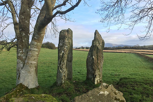
The simplest type of monument with which we deal is the standing stone, or pillar stone, and being simple, it has many purposes, and a long range of date. Standing stones sometimes mark burial places, were sometimes boundary or landmarks, but without excavation it is not possible to say what purpose was served by an individual specimen. Their erection was begun by the megalithic builders, but they continue until much later times, even after the coming of Christianity, some of these later examples having crosses inscribed on them. Standing stones are numerous in Inishowen as elsewhere in Ireland. A particularly fine example is that at Ardmore, near Muff, and this is of special interest, because it is inscribed with cup and circle markings – a type of Bronze Age carving which gives evidence of inspiration in Ireland from ornament found on rock surfaces in the Iberian Peninsula.
Prehistoric man was, of course, concerned with other things than death and ritual, and we must consider what evidence for these other activities we can find in Inishowen. It is difficult to say anything about the types of habitations occupied in the area during prehistoric times. On the sandhills near Buncrana and on the Isle of Doagh numerous flints were found; among these are flint lozenge-shaped arrowheads which are the earliest type (Neolithic or Early Bronze Age), and tanged-and-barbed flint arrowheads of Bronze Age date. These give evidence of habitation, probably seasonal, on coastal sites.
Stone axe-hammers, with perforations to take a wooden handle, a type ascribed to the Bronze Age, have been found at Muff, Magheralahan, Carrowmore and Ludden. In addition, a large number of stone axes, which however cannot be clearly dated, have been found in Inishowen.
Flat bronze axes, some beautifully decorated (e.g., one from Carrowen) and some other finds give evidence of Early Bronze Age activity. The Middle Bronze Age is represented by daggers (including one with a horn handle found in a bog at Glack), axes and a bronze spearhead. A leaf-shaped sword, a spearhead and a few other finds continue the story to the Late Bronze Age.
Of the greatest interest is the collection of soap-stone moulds from Ballyliffin, intended for casting bronze palstaves (a type of axe with flanges and stop ridge). These moulds give important evidence of industrial activities of the Bronze Age craftsmen. Since some of the moulds are unfinished it is clear that they were being manufactured on the spot, and from a type of stone which is known to be available in Donegal.
The most spectacular Bronze Age find from Inishowen is one discovered early in the 19th century, but of which the precise locality is not recorded. The find consisted of a collection of gold ornaments known as torques, made of twisted gold ribbon, and dating from the first half of the Bronze Age. Fourteen complete torques of various sizes were found as well as some broken fragments, and they give clear evidence of the wealth of their prehistoric possessor. A gold ornament of a different type, a small dress fastener, was found at Glengad, parish of Clonca, in 1863. It belongs to the Late Bronze Age.
It is said that a bronze axe was discovered at Drumfin Rath, on Inch Island. Since we know from excavations elsewhere in Ireland that raths can be as early as Late Bronze Age time, it is possible that some of the numerous examples in Inishowen were occupied during this period, but since this type of habitation continued to be constructed until a much later date, we must assume that the majority are later than the period with which we deal. Though we may certainly suppose that some were occupied during the Early Iron Age, no find of Early Iron Age date is found in Inishowen.
3D renderings of stone age tools from Donegal County Museum’s Collection
The King’s Grave is an extraordinary megalithic site in the townland of Carnaghan. Two massive stones, 3 meters in height sit in front of a covered Portal Tomb. While incomplete, the site is still impressive, and it appears the two standing stones are from one larger piece of rock, with matching internal surfaces. The site was excavated in the 1930s and a food vessel was found near to the tomb, though this may have been associated with later activity around the site.
Further images of the King’s Grave on the CINE Project Flickr account
Legend has it that Fergus McRoy, King of Ulster is buried here, and that his spirit sang the Táin Bó Cuailgne to Seanchan’s son, when the original tale had been forgotten.
The images below are text from Harry Percival Swan’s work, a line drawing of the food vessel, now in the care of the National Museum, Dublin, and a photo of a similar vessel, excavated in Burt, on the land of Stewart Buchanan.
The King’s Grave isn’t the only ancient burial unearthed on the island, as this clipping from 19th Century shows. The food vessel unearthed is in the National Museum.
Aerial drone footage of the site, taken by Cinematic Sky as part of the CINE Project.
There is evidence of at least seven Bronze through Iron Age ring forts on the island, three of which are promontory forts on the south, west and north of the island, and the remainder inland. Doonalin and Dunfinn are marked on the 25” map, their name deriving from the Irish for fort, Dún. There is still ample evidence of both named forts and the large ring fort in Baylet, though the others have been ploughed-out.
It is likely that Inch Fort, the Napoleonic-era British military battery on the north of the island, is built on a previous fort from antiquity, though there are no archaeological traces. Inch Fort is situated on a rocky promontory overlooking the Swilly, with uninterrupted views of the upper reaches of the lough, towards Letterkenny, the western shore beyond Rathmullan, and the eastern shore beyond Buncrana. The promontory was known as the Down of Inch, once again derived from Dún.
A further possible fort in Moress is under investigation.
View of Dunfinn (circled), and Cairn Hill, taken from the King’s Grave.
Local lore tells of Dunfinn being the fairy fort, a claim we cannot prove, but during the research, we left a token and bowed to the little folk when we passed.
Boyd Bryce tells the story of the last known sighting of fairies at Dunfinn
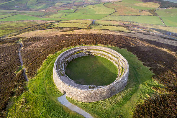
The massive ringfort, or cashel, of An Grianán sits atop Greenan mountain, overlooking Inch, with spectacular views over Lough Foyle, Lough Swilly and the surrounding countryside. The main structure is thought to have been built by the Northern Uí Néill, rulers of the ancient kingdom of Aileach, ca. 500 to 800 CE.
The interior of the circular fort measures some 23 metres across and an entrance passage extends through the thickness of the massive encircling wall. This dry-stone wall stands some 5 metres high and incorporates a series of terraces that are accessed by stone steps.
The monument clearly has ancient origins and surrounding the stone fort are the remains of a much older hillfort that was most likely constructed around 1000 BCE. There is also a small stone cairn nearby that is most likely a burial monument from the Neolithic or Early Bronze Age. The original fort was sacked in 1101 by Uí Néill rival, Murtagh O’Brien the king of Munster.
The ruins of Grianán of Aileach were first surveyed the 1830s by George Petrie. The current hillfort, after the restoration of 1874–1878, is substantially different but much of the old structure remains intact. During the restoration, it was found that parts of the original drystone masonry had been preserved under the collapse. The workers marked, in tar, the undisturbed portions of the cashel and used the collapsed stone to build on this foundation.
It is possible the fort is mentioned on Ptolemy’s 140 CE map of Britain and Ireland, where a place of kings, Regia, is marked in the north-west corner of Ireland. The fort is now under the care of the National Monuments Service.
During our conversations with the islanders, An Inis na n-Osirí was a name we heard a number of times, though we could find no specific reference to this, the island’s Irish name. In the course of further research, we discovered two documents that mentioned Inch of the Oysters; from the Bargain and Sale of Inch in 1603, ‘Inchneoystre’, shown below, and from the records of the Earl of Donegall in 1768, the Island of ‘Innishostree’.
A large number of oyster shell middens have been recorded on the eastern, southern and western shores of the island, some several metres deep. From the extent and depth of these middens we can be certain that the shellfish in Lough Swilly were a major source of protein and calcium for the early inhabitants of Inch.
The shell middens are an excellent source of lime for both fertiliser and mortar, and were quarried extensively during the last four hundred years. Oysters are still farmed on Inch’s strands today. Boyd Bryce talks about the oyster shell quarry in Mill Bay.
Mura was a disciple of St Colmcille and was appointed by him as abbot of Othan Mór monastery at Fahan, Co Donegal.
After Mura’s death of the saint it was called Fahan Mura. Mura wrote a rhymed life of St Colmcille, which is quoted in the Martyrology of Donegal (1630). He is regarded as the special patron of the O’Neill clan, being a descendant of Niall of the Nine Hostages, through his son Eoghan, who gave his name to Inishowen.
Three testimonies of his ministry survive: his crozier (Bachall Mura), now in the Royal Irish Academy; a bell-shrine, now in the Wallace Collection, London: and a stone cross preserved at Fahan as a national monument.
This early 7th century cross-slab is 2 metres tall, and its design demonstrates a close connection with Scotland, where the shape is more common. The intertwined ribbon knotwork is thought to represent the Tree of Life and the five circles symbolizing fruit. The Tree of Life with its roots on the earth and its branches high in the air symbolized a connection between heaven and earth. The seasonal cycles of the tree link it with growth, death, and rebirth.
Though nothing remains, it is probable that an oratory was built on Inch, at Strahack; a place of prayer across the channel from Fahan. The Christian burials there are contained within the walls of the graveyard.
Aerial drone footage of the site, taken by Cinematic Sky as part of the CINE Project.
Strahack Graveyard from CINE Donegal on Vimeo.
Oral history from the family that owns the land, tells of a small building beside the graveyard, with the remains of an arched window, now lost.
Further images of Strahack on the CINE Project Flickr account.
Inis Eóghain (Inishowen) was the original homeland of the Cenél Eóghain and from which they expanded over much of Ulster. The original capital of the Northern Uí Néill lay within its southern boundaries at An Grianán Ailigh. The territory of the Cenél Eóghain stretched from the tip of Inishowen to the Blackwater area near Armagh.
In the 12th and 13th centuries the kingship of the Cenél Eóghain was disputed by two families the Mac Loughlins and O’Neill. By 1196 Hugh O’Neill held the kingship until his death in 1230 except for a brief period in 1201 when Mac Loughlin wrested it back. After Hugh’s death, Donnell Mac Loughlin succeeded to the kingship after disposing two O’Neill claimants. In 1241 the Mac Loughlins assisted by the O’Donnells of Tirconnell battled with Brian O’Neill at Caimirighe. In the process Donnell Mac Loughlin as well as ten O’Donnell claimants to the Cenél Eóghain kingship were slain. Following which the MacLoughlins diminished to a minor clan in Inishowen while the O’Neills gained full control and from whom the territory known as Tír Eóghain (Tyrone) evolved.
In 1280 Niall O’Neill was described as the king of Inishowen, however by 1300 the peninsula was in the possession of the Earl of Ulster. Following the earl’s death in 1333 ownership of Inishowen was gained by the O’Doughertys from Tirconnell.
1807 sketch of Inch Castle by Captain William Smith
Click image to see more from the CINE Donegal Flickr account.
The ruins of O’Doherty’s castle are located on the south-western tip of Inch. The castle was constructed around 1430 by Neachtain O'Donnell for his father-in-law Cahir O'Doherty. The O'Doherty's were the dominant family on the nearby peninsula of Inishowen and had close links with the O'Donnells. The castle was part of the defensive network of fortifications designed to protect the O’Dohertys from rival clans - Inch, Burt, Elaghmore, Greencastle, Redcastle, Whitecastle and Carrickabrachy. The ruins stand on the location of an earlier promontory fort, overlooking the approaches to Burt and Letterkenny.
An entry in the Duchas Schools Project mentions the use of oxblood to strengthen the mortar (another mentions goat’s milk). According to many historic sources, oxblood was used specifically for its hydrophobic properties, and hydraulic mortars with blood addition were frequently described as hard, adhesive and durable. The roof of the Pantheon in Rome is reputedly constructed in concrete reinforced with volcanic ash and oxblood, two animals a day losing their lives.
In Swan’s ‘Book of Inishowen’, the grim tragedy of Inch Castle is detailed. In 1454, Donnell and Rury O’Donnell, rival claimants for the Lordship of Tirconnell, were pitched against each other. Donnell was arrested and held in chains in the castle’s dungeon. When Rury arrived, he ordered the castle to be razed. Donnell was loosed from his chains as his dying request. He made his way to the top of the castle, through the flames, dislodged a stone and hurled it from the battlements at Rury. The unfortunate Rury was struck on the head and died immediately, leaving Donnell clear to claim the Lordship of Tirconnell. The scene is depicted in Roderic O’Donnell’s 1854 engraving.
When the castle and lands of Inch were granted to Sir Arthur Chichester in 1609, he stated that it was in a state of disrepair.
The last resident of the castle was Fanny McCloskey, as related in the Duchas Schools Collection.
Aerial drone footage of the site, taken by Cinematic Sky as part of the CINE Project.
A 3D rendering of the castle
Please Note: the castle is on privately-owned farmland, and permission to visit should be sought from the landowner. Please shut all gates and leave the site as you find it.
The 16th and 17th Centuries were a time of conflict, rebellion and great change in Ireland. The following text is from a Donegal County Council Archives exhibition, produced for the 400th anniversary of the Flight of the Earls.
Late Medieval Ireland was made up of three distinct cultures: Gaelic Ireland, the Anglo-Normans or old English and those who were more recently arrived and lived primarily within the Pale.
The Anglo-Norman lords recognised the king of England as their ruler, but they lived far from London and often adopted many of the Gaelic customs.
English rule in Ireland was concentrated on an area around Dublin known as the Pale and in small areas centred in larger towns and cities. The people of the Pale kept much closer ties to England and followed English customs and “common law”.
Medieval Gaelic society was a clan or lineage-based society. The economy was based on farming. Barter, especially in cattle, was the common method of business transaction. Settlements were mostly scattered either in isolated farmsteads or in-house clusters. Gaelic society had its own system of law, known as Brehon Law.
Brehons (or brithem) preserved and interpreted the law that had developed from customs passed on orally from one generation to the next. Brehon Law was often in direct contrast to English “common law”. Brehon Law recognised divorce. Wives could keep their own names and property when they married. Children born outside marriage were entitled to a share in their fathers’ property and any male relative of the chieftain could succeed to the leadership. This often led to many heirs in matters of land and lordship which gave rise to the political instability common in Medieval Ireland. Fosterage and hostage taking were used to strengthen alliances and enforce agreement.
In the 16th century Ulster was ruled primarily by Old Gaelic and Anglo-Norman families. The O’Neill dynasty dominated Ulster from their base in Tír Eóghain, which consisted of modern Tyrone, as well as parts of Counties Derry, Donegal, Fermanagh, Monaghan and Armagh.
The political influence of the O’Donnell family, lords of Tír Chonaill, had spread from Donegal across the territories of Fermanagh, Sligo and Leitrim. They were supported by sub- chieftains such as the O’Dohertys, the Mc Sweeneys and the O’Boyles. The O’Donnells kept a tight hold on their territories by eliminating rival claimants and by keeping a large army made up mostly of professional soldiers, Scottish Gallowglasses. The military success of the O’Donnells brought with it wealth. In 1560 The O’Donnell was known abroad as “the king of the fish” because he controlled the greatest share of the Irish fish trade.
In 1541 Henry VIII introduced a scheme of “surrender and re-grant” in an effort to control the Irish lords. If the Gaelic Chieftains surrendered their land to the King and promised to recognise English laws and customs, they were allowed to hold their lands in perpetuity from the monarch and were granted titles. Under this scheme Henry VIII granted the O’Neills the title of Earls of Tyrone.
At the start of Elizabeth I’s reign in 1558 Ulster still lay beyond the reach of the English crown. Throughout the 16th century various attempts were made to subdue the Gaelic chieftains and English power slowly advanced in Ulster.
In the last decade of the 16th century the Gaelic lords felt increasingly threatened by the growing power of the English crown in Ulster. In 1593 the appointment of an English sheriff to Fermanagh led to a revolt by Hugh Maguire. Maguire soon found support from the other chieftains and thus began the Nine Years War. O’Neill secretly supported the rebels but kept up the appearance of loyalty to the Crown until 1595. He had the most to lose but knew that his authority in Tyrone was also under threat.
Maguire defeated the English at the Ford of the Biscuits in Fermanagh and Red Hugh O’Donnell led successful raids into Sligo, Mayo and North Galway. O’Neill defeated the English at Clontibret in Monaghan, Yellow Ford in Armagh and the Moyry Pass on the Armagh /Louth border. These successes were due in no small part to O’Neill’s military skills as well as to the fact that the battles were fought mainly on territory familiar to the chieftains.
To build on these military successes foreign aid was essential. The Spanish were interested in helping England’s enemy and several meetings took place in Donegal. In the meantime however, battles raged within the clans over succession. This, worsened by the delay in the arrival of foreign aid, weakened the ability of the Irish to defeat the English.
The Spanish finally arrived in Kinsale, County Cork, in September 1601. Following an arduous journey from the north, O’Donnell persuaded O’Neill to attack the English force in December. The battle was a disaster. O’Neill’s forces did not surprise the English and they were forced to retreat while the advancing English cavalry attacked them. O’Donnell’s force in the rear guard fled. The battle was soon over. The Spanish Captain, Don Juan del Águila surrendered nine days later to Lord Deputy Mountjoy.
With no army and much of his lordship lost to his cousin Niall Garbh, O’Donnell decided to go to Spain to get further help from King Philip III. He died in Simancas in 1602. He named his younger brother Ruairí as his successor.
During 1603 Mountjoy concentrated his campaign in the northern counties and Leinster. Harvests and stock were destroyed, and famine soon set in. O’Neill returned home. Mountjoy however knew that O’Neill was still a threat. Reluctantly the Queen authorised him to open negotiations with O’Neill. On the 29th March 1603 O’Neill knelt before Lord Mountjoy at Mellifont, County Louth. He swore to be loyal to the crown and not seek further assistance from foreign powers. The Treaty of Mellifont was signed on the 31st March 1603. O’Neill was granted pardon and was restored as the Earl of Tyrone. Ruaírí O’Donnell was created the Earl of Tír Chonnaill.
Although Ruaírí O’Donnell had received a patent from the crown of all the territories in Tir Conaill the patent also stated that the O’Donnells must renounce their claims to the overlordships in areas west and south of Lough Swilly. Niall Garbh O’Donnell who was allowed to hold his own land around Castlefinn directly from the crown, continued to challenge O’Donnells leadership. There was ongoing tension over land between O’Donnell and the other Donegal families, in particular the McSweeney’s and O’Boyles. Furthermore, O’Donnell was constantly antagonised by the actions of the English officials in his territories.
Between 1603 and 1605 O’Neill slowly began to strengthen control over his territories. However, in 1605 O’Neill’s old enemy Chichester was appointed as Lord Deputy. Chichester wanted to civilise Ireland and to get rid of Catholicism from the country once and for all. He was determined to prove that the northern chieftains, in particular O’Neill, were planning treason.
Throughout 1606 royal officials provoked the chieftains who found it increasingly difficult to get support from the Lord Deputy. Rumours persisted that an Ulster presidency was to be set up with Chichester appointed as the royal governor of the north. Furthermore, a succession of royal officials supported the O’Cahan chieftain’s claim to an area of O’Neill’s estate. Finally, in 1607 O’Neill and O’Cahan were summoned to London by King James I to settle their dispute. It was believed that O’Neill and O’Donnell were to be arrested for treason. O’Neill considered that he had no option but to leave Ireland for the continent.
In Inch’s long history, the years 1597 to 1608 are some of the most fascinating, full of intrigue, political manoeuvering and the use of the island as a pawn in the large story of Ulster and Ireland. The characters and story are set out below…
Lord of Inishowen and owner of Inch, sided with the Crown against O’Neill. He was knighted by Lord Mountjoy and the young O’Doherty had ambitions to become a courtier. He was supported by Sir Henry Docwra, who seized Derry in 1600, but Cahir quickly became disenchanted with English rule. He increasingly came into dispute with Irish-based officials such as the Viceroy Sir Arthur Chichester and the Governor of Derry Sir George Paulet.
Born in Flintshire, he served as an officer under Sir Henry Docwra, as part of the expedition to establish garrisons in Derry and the Lough Foyle during Tyrone's Rebellion (1594–1603). Following its capture, Bingley was placed in command of Rathmullan.
"The career in Ulster of Ralph Bingley, a man tolerably representative of the servitor class, impinged on a number of the aspects of change in land ownership… Paid in Ireland as Captain of Foot from 8 August 1598… His immediate background was that of the professional soldier who had attended neither university nor inn of court."
Robert John Hunter
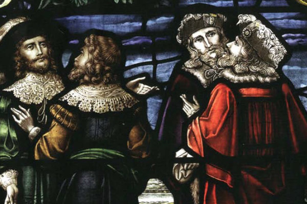
Fowler was a Scottish poet or makar (royal bard), writer, courtier, and translator. He travelled extensively in Europe, and was private secretary and Master of Requests to Queen Anne of Denmark on her marriage to James VI. (shown above left)
Chichester was an English administrator and soldier who served as Lord Deputy of Ireland from 1605 to 1616. (shown above right)
Originally under O’Doherty’s title, lands around Rathmullan and Inch were granted to Bingley in 1602, as a reward for his service. Being a foot-soldier and not well-paid, Bingley sold the island to Fowler and another gentleman, Gerrard Verhoeven, for the sum of £500, the equivalent of almost €300,000 today. Verhoeven, noted as a merchant, may have been a friend of Fowlers or a financier.
This action seems to have been the final straw for O’Doherty who rebelled in 1608, sacked and razed Derry, and murdered Paulet. O'Doherty's precise motives for the rebellion are unclear, as the Privy Council of Ireland had just ordered that the remainder of his lands be restored to him. The sale of Inch, the most fertile land in Inishowen, and land to which he had title, incensed O’Doherty, and revenge against the perfidious Crown administrators may have been reason enough. O’Doherty was killed at the battle of Kilmacrennan, in July 1608, and his lands were forfeited. His head was taken to Dublin and displayed over Newgate as a deterrent to further insurrection.
O’Doherty was killed at the battle of Kilmacrennan, in July 1608, and his lands were forfeited. His head was taken to Dublin and displayed over Newgate as a deterrent to further insurrection.
On hearing of O’Doherty’s death, Chichester immediately seized control of the entire estate. In what we can assume was not much more than a handshake-deal, Chichester swapped land in Fermanagh with Fowler for the island of Inch. Chichester’s descendants became the Lords Templemore.
A footnote: There may be much more to this tale, but even the little we know would suggest the island was a valuable and much sought-after piece of Donegal. When the Cunninghams from Ayr were granted lands, some of those acres were on Inch. In the scramble for land and the confusions over title, Chichester had to act as mediator in a disagreement between the Cunninghams and Bingley.
“As, for instance, it falls out between Sir James Cunningham and others, who have deficient proportions, and Sir Ralph Bingley, who, purchased some abbey lands both in the King's time and before, upon a part whereof he built certain houses and two profitable mills, within four miles of the Derrie, and which are now adjoining Sir James Cunningham's proportion. Sir James has informed the King that Sir Ralph detains the lands which of right belong unto him and to his uncle James Cunningham. Whereupon the King, by letters of the 21st of April last, required me to send for the parties or their attornies, and upon examination to put the said Sir James Cunningham and the rest into peaceable possession of the lands in controversy, according to the tenor of their letters patent. But if the same should appear to be on Sir Ralph Bingley's side, then I am to endeavour to compound the matter equally between them.
I have examined Sir Ralph's title in presence of both parties, and find the same to be good in law, though not favoured in the inquisitions. Thereupon we dealt with him for a reasonable price on the King's behalf, and in the end offered him £500. by way of proof, but he seriously affirmed that he would not part with the mills and land under £800. sterling, or a book of feefarm of 100 marks a year, or the lease of the King's other concealed lands wheresoever within the realm to be found. To yield to either of these in this case is like to be of very ill consequence. But to avoid all this great charge to the King and trouble on every side, there are already sufficient concealments discovered among the escheated lands in Ulster to content all men.
Dated Dublin, 11th Feby 1613”
The following text is from a Donegal County Council Archives exhibition, produced for the 400th anniversary of the Flight of the Earls.
Hugh O’Neill was in Slane, County Meath when word reached him on the 6th of September 1607 that Cúchonnacht Maguire had arrived with a French ship, hired to bring the Irish Earls to Spain. The ship was harboured in Lough Swilly near Rathmullan. O’Neill travelled from Slane to Mellifont on the 8th of September and from there on to Dundalk. His route then took him over Sliabh Fuadh to Armagh and then to his home in Dungannon, County Tyrone. From there he travelled over the Sperrin Mountains and was met in Ballindrait in County Donegal by Cathbharr O’Donnell. Together they travelled to Rathmullan where Ruairí O’Donnell and others were loading the ship.
Ninety-nine people in total departed for the continent on the 14th of September from Portnamurry near Rathmullan. The passengers assembled in such a hurry that O’Neill’s infant son could not be retrieved from his foster family and they were forced to leave without him. Ruairí O’Donnell also left behind his young and heavily pregnant wife, Bridget. Thirteen days into the journey, heavy storms diverted the ship from its intended destination of Corunna in Spain and they headed for the north of France. On the 4th of October the ship landed at Quilleboeuf on the Seine River near Rouen.
The Earls were eager to travel to the safety of Spanish controlled Flanders. They travelled east and reached Louvain, in Belgium in November 1607. They spent the winter at the Irish Franciscan College, awaiting news from the Spanish King. Having received no word from Spain by February the Earls set out for Rome, leaving the children and some of the women in Louvain. After a difficult journey over the Alps they reached Rome on the 29th of April 1608. The party were made welcome and Pope Paul V granted them the hospitality of the Papal Court.
In the summer of 1608 Cahir O’Doherty’s rebellion in Inishowen made O’Neill impatient to return to Ulster. He wrote to Philip III on the 9th of July to say that they should ‘not allow that such a good opportunity be lost’. International relations in Europe at this time were complex and the King was slow to commit Spain to open support for the Irish rebels. O’Doherty’s death in July and the subsequent suppression of the rebellion put paid to O’Neill’s efforts to return to Ireland at this time.
By the end of the summer of 1608 Ruairí and Cathbharr O’Donnell and Cúchonnacht Maguire had all died from fever. The O’Donnell brothers were buried in the Church of San Pietro Montorio in Rome. O’Neill continued to write to the King of Spain up until the year before his death, still waiting for the opportunity to return to Ireland. He died of a fever on the 20th July 1616 and was buried along with the O’Donnell’s in Rome.
Turas na dTaoiseach/the Departure of the Lords, Tadhg Óg Ó Cianáin
"In the name of God.
Here are some of the adventures and proceedings of Ó Néill from the time that he left Ireland. First, Ó Néill was with the Lord Justice of Ireland, Sir Arthur Chichester, at Baile Shláine. He received a letter from John Bath on Thursday, the sixth of September, the year of the Lord at that time being one thousand six hundred and seven. It was stated in the aforesaid letter that Maguidhir (Cúchonnacht Maguidhir), Donnchadh Ó Briain, Matha Óg Ó Maoltuile, and John Rath came with a French ship for Ó Néill and the Earl of Tyrconnell to Cuan Suilighe moire, opposite Ráth Maoláin in Fánaid. Ó Néill took his leave of the Lord Justice on the following Saturday.
He went that night to the Mainistir Mór, where Sir Garret Moore was. On the following day he went to Srádbhaile, Dúna Dealgan. He proceeded on Monday from Srádbhaile by the high road of the Fiodh, to Beal Atha an Airgid, across Sliabh Fuaid, to Ard Macha, over the Abha Mór to Dun Geanainn, to the Craobh, one of his island habitations. He made a stop and a rest at Craobh on Tuesday. He proceeded in the name of God from Craobh on Wednesday over Sliabh Síos. He was that night in Muinntear Luinigh, in the vicinity of Loch Beigfhine. On the following day he reached Bun Diannoide. He rested from mid-day till nightfall. After that he passed over Fearsaid Mór on Loch Feabhail, straight forward to Droichead Adhamhnáin.
The son of Ó Domhnaill (Cathbharr, son of Aodh, son of Maghnus) was there awaiting them. They went to Ráith Mealltain, the daylight shining, upon them at that time. They proceeded to Ráith Maoláin, where the ship we have mentioned was at anchor. They found Rughraighe Ó Domhnaill, Earl of Tyrconnell, with the aforesaid gentlemen, together with many of the tribe and followers of the Earl, putting stores of food and drink into the ship.
They went in on board ship about midday on Friday. Then they hoisted their sails. They moved close to the harbourside. They sent two boats' crews to get water and to search for firewood. The son of Mac Suibhne of Fanaid, and a party of the people of the district came upon them in pursuit. They fought with one another. With difficulty the party from the boats brought water and firewood with them. About the middle of the same night they hoisted their sails a second time. They went out a great distance in the sea. The night was bright, quiet, and calm, with a breeze from the southwest. Then they proposed putting into Ara through need of getting food and drink. An exceeding great storm and very bad weather arose against them, together with fog and rain, so that they were driven from proximity to land. They traversed the sea far and wide. That storm and unsettled weather lasted till the middle of the following night."
Links:
As the Plantation began, Inch was owned by Arthur Chichester, Lord Deputy of Ireland. He surrendered tracts of land to the King’s Grantee, the Duke of Lennox, including thousands of acres in the Laggan and in Inishowen. Lennox brought with him undertakers, Cunninghams from Ayrshire, as well as many families – and surnames – known on Inch today. Chichester did retain some land on Inch, which were passed on to his younger brother and eventually became the seat of the Lords Templemore, at Inch House.
The Ulster Plantation booklet, produced by Donegal County Council Archives is a concise and clear investigation of this period.
Plantation architecture and landscape in Derry and Donegal, produced Donegal County Council and Derry City Council explores the legacy of built heritage from the Plantation.
Rev George Hill’s A Historical Account of the Plantation of Ulster is an immensely detailed account of the Plantation, uploaded to Google Books.
The Brown family of Inch - ferrymen, fishermen and boat builders - were one of the best-known families on Lough Swilly for many generations.
In 1611, James VI granted James Browne, gent, a licence to operate ferries in Donegal. The family were still running ferries across the Swilly into the 1950s, and fishing in the 1980s.
Written by John Niven, son of Violet Brown, this is a short history of the Brown Family.
This picture of the SS Lake of Shadows (ca late 19th Century) shows the Brown’s home place on Lackan Point, Inch – the white cottage above the prow of the ship. Photo by Robert French, from the Lawrence Collection, National Library of Ireland.
Boyd Bryce tells of the Brown’s homeplace and the story of the Western Men.
The Inch people had to come over to Burt in boats and it is said that someone sat at a window in the gallery of the church with a view of the water and at the critical moment, when the tide was right, stood up and announced “The Inch folk may go now”.
James Buchanan has written an extraordinarily rich History of the Burt and Inch Presbyterian Church.
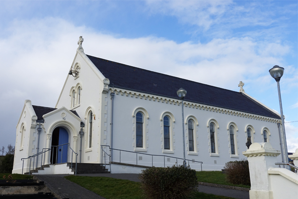
The current meeting house on Inch, dates from the 1860s.
Further images of Inch Presbyterian Meeting House on the CINE Project Flickr account
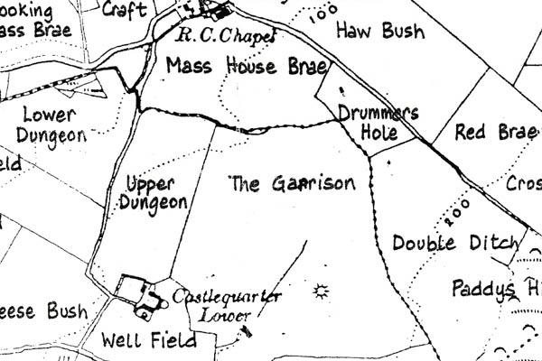
In 1689, as Derry was besieged by the forces of James II, Williamite forces landed on Inch and set up a garrison.
The booklet Inch and the Siege of Derry, is a detailed exploration of that event, and is reproduced with the permission of historian and author, Richard Doherty
The Garrison Field, possibly the location of the encampment, is located in the townland of Castlequarter, close to Mill Bay, a sheltered inlet on the west of the island.
The Penal Laws were a series of laws imposed in an attempt to force Irish Catholics and Protestant dissenters, including Presbyterian congregations, to accept the established Church of Ireland.
Various acts passed in the 16th and 17th centuries prescribed fines and imprisonment for participation in Catholic worship and severe penalties, including death, for Catholic priests who practiced their ministry in Britain or Ireland.
Other laws barred Catholics from voting, holding public office, owning land, bringing religious items from Rome into Britain, publishing or selling Catholic primers, or teaching.
In practice, the Penal Laws saw the establishment of hedge schools across the country, and church services held in secret. On Inch, the Mass Rock was located at Moress Point.
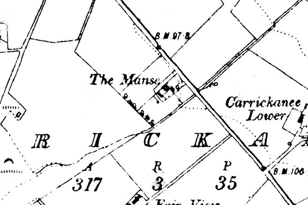
Built in the Queen Anne style, The National Inventory of Architectural Heritage gives a date of ca.1730. Inch house overlooks the channel between Inch and Fahan.
Originally built by the Earl of Donegall, the years the house has had numerous owners and lessors, including Swettenhams from Derry in the late 1700s, in 1837, one J. Kennedy esq.
In the mid 1800s, it became the residence of Lord Templemore’s steward, Isaac Colhoun. During the famine, a shirt factory was built with over 50 looms to provide employment for the island’s community.
During the civil war in the 1920’s the house was surrendered by the republican side to the Free State troops.
In the years following the foundation of the Free State, it managed a thread factory and a deep litter chicken farm. It was used for flower production on a commercial basis and as a private home in the eighties. In the 1990s it became the Ó Dochartaigh Genealogy Centre.
Below is a reminiscence from Bryan Stack of Inch House. It is mostly a memory of an idyllic setting, but the final words remind us of the tragedy of the Troubles.
My mother, Beryl Stack, bought Inch House in the Spring of 1945 for £2500.I think the previous owners were called Temple. It was said to have been built in the reign of Queen Anne [1702-1714]. It had 3 public rooms, 7bedrooms, kitchen and bathroom. There were numerous outhouses and a walled garden. With the tennis court, fields and rookery, the property covered 13 acres.
Because my father, Lt. Col. Rowan Stack, was serving in the British Army our occupancy from 1945 to 1953 was sporadic. At times , the house was let out, often to families with Army or Navy connections. In 1953,my father retired and established a poultry farm using the barns as deep litter houses .He had up to 1000 birds on the premises at one time.
My mother took paying guests in the summer. They both grew flowers, fruit and vegetables and sold these and eggs in Derry and locally. In the early days, a generator and a windmill were their main source of electricity but, after a short time, the Electricity Supply Board took over. Their provisions came from the local shop of James Durnin ,from Burnfoot {McIvers], or from Derry and Buncrana.
My brother Dermot [born in Derry, 1945] and I [born in Burma,1937] spent happy holidays on Inch but were at boarding schools in Dublin and England. One of my brother’s best friends at school in Dublin was Patrick O’Neill, son of Captain Terence O’Neill, Prime Minister of Northern Ireland. Apparently the O’Neills came to tea at Inch House in the late fifties/early sixties without any ceremony or disturbance!
My parents greatly appreciated the warm friendship and support of the people of Inch and would have stayed there for the rest of their lives. However my father became severely disabled by arthritis of both hips. After two operations, he decided to retire to England. They sold the house in the summer of 1969 to Paul Shepherd who was a teacher in Derry.
Only a short time after afterwards, one of our friends Marcus McCausland, from Drinagh ,Co. Derry visited the Shepherds at Inch House and was murdered by the I.R.A. on his way home.
The house has many of the original features still in existence such as corner fireplaces and bolection panelling. The gardens are adorned with mature trees from a bygone age; lime, pineapple scented magnolia and overhanging rhododendron to mention a few. Across the courtyard lies the beautiful cut stone stable block, believed to have been built for staff and soldiers at the time of the Napoleonic emergency. During renovation the current owner discovered many beer bottles underneath a basement window, dating from 1670 to 1730 and very likely to have come from ships visiting the area at the time.
During the early stages of the Peace Process Inch House played a part by hosting several meetings between politicians and clergy. One of the finest events was a lunch attended by senior clergy with guest of honour, Mr John Hume. The house became a focal point for American visitors throughout the Peace Process with many visiting privately. Famous amongst these was Newt Gingrich Speaker of the House. Inch House was also the set location for ITV’s filming of Agnes Jones.
The National Inventory of Architectural Heritage has produced a booklet looking at the Architectural heritage of County Donegal.
Donegal County Council’s mapping section has archived the survey of Built Heritage on Inch.
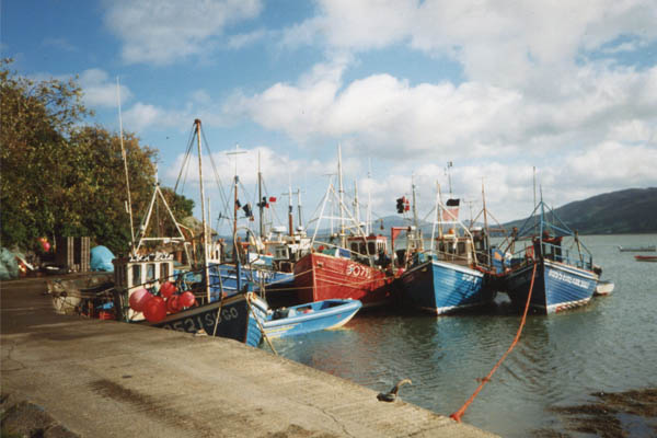
“Here is the great resort of vessels for the herring industry; it begins the middle of October, and ends about Christmas… last year 500 boats were employed in it: the farmers and coast inhabitants build them and send them out.”
The waters of the Swilly were so full of herring that it was said, ‘it was difficult to row through them.’ In 1780, Arthur Young toured Ireland and reported on the fishing industry of Inch, owned and operated by the Alexander Family, who may have used Inch House as a residence and centre for administration.
The herring station, on the north of the island, was sketched by Captain William Smith during his time on Inch, designing and supervising the Napoleonic-era fortifications at the Down of Inch. These images are from his archive at Trinity College Dublin.
Inch’s herring station (circled), 1799
Our CINE Project partners, Timespan, produced a virtual reconstruction of the herring industry in Helmsdale, Scotland, in the 1890s.
“Ah, it was a tedious old crop, flax, right enough, and it was a hungry greedy crop too, but the fields around the Cleggan were good flax fields, and there was money in it. I miss it, its beautiful blue colour. The fields were the colour of a summer sky, and when it was scutched it was so golden that it burned and glimmered as the sun and moon had mixed and fallen on it.”
P. Devlin, The far side of the Lough
The Irish linen industry was also vital to the economy of Donegal, and Inch’s rich soil was ideal for growing flax. In 1796, the Irish Linen Board published a list of nearly 60,000 growers of flax across Ireland. Spinning wheels were awarded based on the number of acres planted. People who planted one acre were awarded 4 spinning wheels and those growing 5 acres were awarded a loom. The Board’s list includes 28 growers on Inch, with some familiar names, though unfamiliar spellings.
Inch’s landscape has evidence of six mills, four for scutching the flax, and two for threshing grain.
A complex series of mill races, ponds and dams stretched across parts of the island. A number of these races consisted of underground, stone-lined tunnels, their outlets still visible today.
Further images of the mill races on the CINE Project Flickr account
Built in 1776, with a vestry added 1869, the Church of Ireland is now a ruin, surviving as a picturesque reminder of almost two hundred years of religious worship and burial. The avenue of yew trees enhances its character in the landscape.
Further images of the church on the CINE Project Flickr account
The Island of Inch Masonic Lodge Number 589 was constituted in 1781, and is one of the oldest continuously active lodges in Ireland.
A detailed history of the lodge was written in 1994 by Worshipful Brother Ian Bartlett. It is not only a glimpse into the records of the lodge, but also fascinating social history of Inch.
The lodge kindly gave their permission to scan the document and a copy can be viewed at this link The History of the Island of Inch Masonic Lodge Number 589.
Further images of the lodge and Masonic history on the CINE Project Flickr account
The Lodge no longer meets on Inch, based now in the Freemasons Hall, Bishop Street, Derry. Their website is here.
The end of the 18th Century was a time of political and social upheaval across the world. Revolutions in America and France had turned the world order on its head. The loss of America, the rising influence and power of Napoleon Bonaparte, and France’s ambitions in Europe had sown confusion and fear within the corridors of British power.
Even on the quiet, agricultural land of Inch, the events of the world outside would change the island, and the lives of the islanders profoundly.
The Society of United Irishmen, founded as a Radical or liberal political organisation in 18th-century Belfast, Ireland, initially sought Parliamentary reform. It evolved into a revolutionary republican organisation, inspired by the American Revolution and allied with Revolutionary France. It launched the Irish Rebellion of 1798 with the objective of ending British monarchical rule over Ireland and founding a sovereign, independent Irish republic.
The National Archives produced The United Irishmen: 17 facsimile documents relating to the rebellion of the United Irishmen in 1798.
In the present great era of reform, when unjust Governments are falling in every quarter of Europe; when religious persecution is compelled to abjure her tyranny over conscience; when the rights of man are ascertained in theory, and that theory substantiated by practice; when antiquity can no longer defend absurd and oppressive forms against the common sense and common interests of mankind; when all Government is acknowledged to originate from the people, and to be so far only obligatory as it protects their rights and promotes their welfare; we think it our duty, as Irishmen, to come forward, and state what we feel to be our heavy grievance, and what we know to be its effectual remedy. We have no national Government— we are ruled by Englishmen, and the servants of Englishmen whose object is the interest of another country, whose instrument is corruption, and whose strength is the weakness of Ireland; and these men have the whole of the power and patronage of the country as means to seduce and subdue the honesty and spirit of her representatives in the legislature.
The Declaration of the United Irishmen, 1791, by Theobold Wolfe Tone
Let no man write my epitaph; for as no man who knows my motives dare now vindicate them, let not prejudice or ignorance asperse them. Let them rest in obscurity and peace, my memory be left in oblivion, and my tomb remain uninscribed, until other times and other men can do justice to my character. When my country takes her place among the nations of the earth, then, and not till then, let my epitaph be written. I have done.
Robert Emmet’s speech at his trial.
With unrest in Ireland and a disorganised militia, Sir Ralph Abercromby (pictured above) was appointed Commander in Chief of British forces in Ireland. He recognised Lough Swilly was a potential location for a French invasion and sent a memo to the War office to that effect. After the United Irishmen Rebellion and the capture of Wolfe Tone in 1798, and the fear that French intervention in Ireland may foment further insurrections, defences were hastily constructed along the southern and western approaches to Ireland. After Robert Emmet’s rebellion in 1803, focus turned to Dublin, with concerns that the French may try a coup de main in Ireland’s capital.
Martello Tower at Mucamish Point, Donegal
No sooner had the Martello towers been constructed, the direction of perceived threat changed again after the battle of Trafalgar. Sir Arthur Wellesley, Chief Secretary in Dublin, believed a landing on the west coast may be more likely, and defences were put in place, with Martello towers erected in Wexford, Waterford, Cork, Bantry, Galway, Lough Swilly and Lough Foyle.
Further defences were planned, including batteries along the shores of the Swilly, including Inch.
1799 sketch of the Down of Inch battery, by Captain William Smith
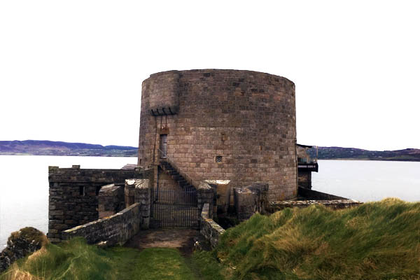
The history of Inch Fort is a tale of geography, paranoia, rebellion, Imperial aggression, itinerant labour, arms-races, civil war, and more recently, the foundation of a spiritual community.
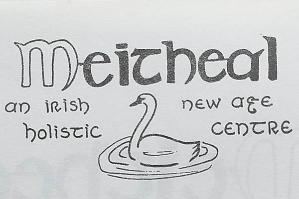
Although the fort is in now private ownership, and closed to the public, the CINE Project was granted access by the current owners, and we would like to offer our gratitude to the Meitheal Trust for that privilege.
The remains of the fort are situated on the Down of Inch, a rocky promontory on the north of the island, with beaches on either side. The promontory’s name may be from the Irish Dún Inis, meaning the Fort of Inch. Although there are no archaeological records to indicate there was any form of structure there in antiquity, the wide views over Lough Swilly, and the physical geography, would suggest the Down of Inch as being an ideal location for defensive fortifications.
With the threat of a Napoleonic invasion, Lough Swilly became one of the most heavily defended stretches of open water in Ireland. The Lough’s depth, lack of strong current and shelter, as well as its proximity to Derry, made it an ideal deep-water port for an invasion fleet.
The pervading paranoia of the time is amply demonstrated by this advertisement from the period.
In 1802 a series of eight temporary forts and batteries were built at Dunree, Ned’s Point, Saltpans, Fahan, Inch, Rathmullan, Mucamish and Knockalla. After Emmet’s rebelioon and with further concerns about Naploeon, six forts were built along the lough shores, replacing the earlier fortifications.
Click image to see more from the CINE Donegal Flickr account.
The forts were designed along similar lines, taking account of the topography of the sites. Their construction was supervised by Captain William Smith. His sketches of the proposed sites are archived in Trinity College Library.
In their original incarnation, the forts consisted of a tower, with roof mounted howitzers, and defensive walls, with emplacements for cannon. The howitzers offered a high trajectory of shot, their purpose, to penetrate the decks of any enemy ship. The cannons were of greater calibre and range, their purpose, to engage with any potential aggressor and destroy ship’s cannon. Inch Fort had a total of nine guns - three 5.5” howitzers and six 24 pounder cannon.
During the construction of Inch Fort the engineers appear to have commandeered and demolished the herring station, as no trace of the fish processing buildings are evident on the 1837 maps of Inch.
The forts of Lough Swilly were designed to create an impenetrable defensive field of fire, protecting the Lough and the landing points along its shores. Military historians have suggested any naval incursion to a protected harbour would have required a three-to-one superiority in ship to shore armaments, and as the ships were at the mercy of the wind and tide, the shore guns would inevitably be more accurate.
The artillerymen manning the forts were members of the Royal Artillery, who came under the command of the Board of Ordnance. Their distinctive blue uniforms were worn until the early years of the 20th Century. Inch fort was built to accommodate 2 officers, 5 bombardiers and 80 gunners but never saw a garrison of this size.
The cannons installed at Inch were most likely of design known as a Blomefield, as Dr A.R. Collins writes.
“The Napoleonic Wars were fought and won with Blomefield guns and carronades.”
The fort was briefly operational from 1813, but the actions of Sir Arthur Wellesley, now the Duke of Wellington, at Waterloo in 1815, made the Swilly Forts obsolete. Napoleon’s defeat saw the garrison at Inch Fort reduced to 8 men by 1823. By the middle of the 19th century, Inch fort was minded by one invalided soldier.
Few images exist of the fort as it was built, but in the National Library’s Lawrence Collection, there are a handful of photos by Robert French, including this view of Rathmullan, with Inch Fort across the channel.
Detail shows the Martello Tower and original fortifications.
Bizarrely, French’s photograph, taken before 1890, was used in a German Wehrmacht Invasion manual from WWII, demonstrating once again, the value of the Swilly as a deep-water port, and foothold for invasion.
Footnotes
Captain Smith was occasionally the victim of some less-than-satisfactory workmanship, as this sketch of the collapsed tower at Knockalla Battery shows.
His comment beneath reads…
“Sketch of the tower at Knockalla fort made after the fall there of in order to show the infamous work made there in by the contractor having been foretold by Captain Wm Smith assistant Engineer prior to same in 1815.”
The traditional buildings of Inch - cottages, barns, mills, the herring station, and even the original incarnation of the fort - were constructed from local materials found on the island – quarried stone, bound with lime mortar, occasionally protected with lime-based dash or smooth lime render.
The 6” map from the mid-19th Century shows two quarries close to each other.
The existing lime kiln at Carnaghan dates from 1880, though undoubtedly there was a previous building on the site or nearby. The local stone was quarried and heated in the kiln, before being slaked with water to produce the lime. The method is practiced around the world and unchanged for centuries.
The kiln worked until the mid-1920s, the quarries even later, supplying stone for new roads on the island.
Boyd Bryce speaks about the lime kiln and its history below:
Between 1829 and 1842 Ordnance Survey Ireland completed the first ever large-scale survey of an entire country. Acclaimed for their accuracy, these maps are regarded by cartographers as amongst the finest ever produced. The work was overseen by Thomas Colby, an officer in the Royal Engineers, who overcame the loss of one hand in a shooting accident to begin in 1802 a lifelong connection with the Ordnance Survey.
Colby’s most important work was the Survey of Ireland. He began planning this enormous enterprise in 1824 and directed it until 1846, in which year the final maps made by the survey were almost ready for issue. He was the inventor of the “Colby Bar” (a compensation bar, pictured above), an apparatus used in base-measurements.
In 1827–8, under his superintendence, the eight-mile-long Lough Foyle Base-Line was measured between Ballykelly and Magilligan. From this base-line, the Ordnance Survey triangulated points across Ireland to create the basis for the first accurate map of Ireland.
The 6 inch and 25 inch maps on Geohive come from Colby’s work.
In the Ordnance Survey Memoirs of Ireland, Mr. Montgomery reports on Inch, though he appears little impressed with the cartographer’s progress.
The first Lord of Templemore was Arthur Chichester, the grandnephew of the Arthur Chichester who claimed the forfeited lands of Cahir O’Doherty in 1608. The map below is from the Down Survey of Ireland, 1650 showing the forfeited lands of Enishowen, with Inchy Island at the bottom right.
The latter Chichester was elevated to the peerage on the coronation of William IV in 1831, becoming the 1st Baron Templemore. His seat, was Inch House on the island.
In the mid 19th Century, the 2nd Baron Templemore, Henry Spencer Chichester, employed a Land Steward, Isaac Colhoun, whose enlightened perspective came to the aid of Inch’s community in the years of the Great Famine. In 1844, Colhoun was interviewed by her Majesty’s Commissioners in their report into the law and practice of land occupation in Ireland.
The Duchas Schools Collection also mentions Arthur Claud Spencer Chichester, the 4th Baron Templemore.
From James Buchanan’s History of Burt Presbyterian Church.
It may be difficult for anyone now to visualise the tidal waters of Lough Swilly rolling inwards past Burnfoot village across to the base of Grianan Hill, and encircling the “Isle of Burt” (Carrowen, Drumgowan, Ballymoney and Grange). Yet such was the position over 150 years ago until the existing embankments were created to connect Inch Island with the mainland on both sides.
The reclamation project originated about the middle of the 18th century by leading merchants of Londonderry and important persons in County Donegal being desirous to establish a canal or waterway to connect Lough Swilly with Lough Foyle, and thus more directly facilitate local coastal trade by shortening the shipping route.
Accordingly, in 1763 and again in 1765 petitions were presented to the Irish House of Commons, Dublin, for aid towards the expense of carrying in into effect, but although favourably received nothing practical resulted. At this time the total expense of the creating of the canal was not expected to reach £8,000. The main idea was merely to cut a waterway from Derry to the sea near Burnfoot, a distance of about five Irish miles, based largely upon vague conjecture and without reliable engineering advice.
In 1807 Londonderry Corporation employed an engineer on the project, but although a survey and report was presented in the following year nothing practical resulted.
A revival of the proposal took place in 1831 when a noted engineer, Sir John Rennie prepared three alternative plans. The First required an embankment extending direct from high water mark near Burnfoot to “Foreland (commonly called Farland) Point”, and the Burt Mill Stream crossed by aqueduct, the total length of canal being seven miles three furlongs and expenditure estimated at £38,462. The second plan indicated the canal, eight miles in length, to proceed along the Burt shore at the base of Grianan Hill and thence to Farland Point, the cost being similar to the first plan. Under the third scheme, the first proposal was to be fulfilled as far as Trady Point with a channel dredged thence to the deep water at Farland Point at a cost of £36,962.
Evidently the cost shocked the promoters, because there followed five years of inactivity. Sir John Rennie’s labours had brought home to all concerned that something more durable and important than cutting a waterway from the Foyle side to the Burnfoot mid flats was essential. It was realised that protection from the rough tides of Lough Swilly would be required to permit the canal to function from high water mark to deep water over a couple of miles. Furthermore, the provision of an embankment would also necessitate an outer protective barrier against sea incursion particularly during strong tides.
Such an arrangement required an extent of land reclamation, and it became obvious that a larger and bolder scheme would prove not only more beneficial for the making of the canal but also produce attractive remunerative results by the creation of an expanse of rich alluvial soil for agricultural purposes.
Accordingly the project was revived in 1836 with the main object of land reclamation from the sea bed not only in Lough Swilly but also in Lough Foyle, and elaborate plans were drawn up by a celebrated engineering expert, Mr Dimsdale. Statutory authority was secured in 1838 by “An Act for draining and embanking certain lands in Lough Swilly and Lough Foyle in the counties of Donegal and Londonderry”.
According to this Act the promoters of the scheme were:
- John Gyllyatt Booth, Crouch End, Hornsey.
- Thomas Isaac Dimsdale, Hanley Road, Upper Holloway.
- Thomas Edge, Peter Street, Westminster.
- John Robertson, Warnford Court, London.
- Francis Stedman, Baron Street, Pentonville.
- Francis William Staines, Charlotte Street, Fitzroy Square.
- James Whiskin, Ashby Street, Clerkenwell.
These gentlemen were stated to all belong to the County of Middlesex. It was stipulated in the Act of 1838 that the Sloblands of Lough Swilly became vested in the promoters, their heirs or assignees “for ever”, but any projected canal to connect Lough Swilly with Lough Foyle was to have free passage through the reclaimed lands.
The undertakers were required to begin the work within two years from the date of the passing of the Act (27th July, 1838), expend £3,000 on or before 31st December, 1841 and attain completion within ten years from the date of enactment.
The work of the Lough Swilly reclamation, as well as that on the Foyle, was carried out by William McCormick, an important Ulster contractor, and for some years M. P. for Londonderry City. Unlike the Foyle reclamation those on Lough Swilly were carried out in their entirety.
The Farland Bank sluice gates regulate the level in the Freshwater.
The Lough Swilly scheme required the erection of four main embankments. The first extends from near the old Tooban Junction on the Londonderry and Lough Swilly Railway for a distance of two and a half miles to Farland Point. It is usually styled “Trady Embankment” from the name of the former small island over which it passes. It was completed in 1850, is stated to have cost £80,000 and encloses over 2,000 acres, the major portion of the land reclaimed. The second embankment, which is a sea rampart, extended from Quigley’s Point on the mainland (near the old Inch Road Railway Station) to the Island of Inch. It is popularly called “Inch Embankment” and was completed in 1855 and along its side is the only public road connecting Inch Island with the mainland.
The third erection, also a sea embankment and usually termed “Farland Embankment” was completed in 1856 and connected the island of Inch with the former “Isle of Burt” near Farland Point. Both the Inch and Farland Embankments were estimated to have cost upwards of £60,000 each.
The Londonderry and Lough Swilly Railway service from Derry to Farland Point in Burt was opened in December 1863 operating on a standard gauge track. This connected with shipping services to Ramelton, Rathmullan and Portsalon.
The English railway engineers, Wagstaff and Brassey, (Thomas Brassey shown above) completed the work on the embankments, but with the project costing so much, McCormick and the undertakers found themselves unable to meet the bill. Wagstaff and Brassey took ownership of the lands in lieu of payment, with nearly 3000 acres in their name being recorded in the 1870s. Brassey’s biographer, Sir Arthur Kelps opens with this somewhat obsequious preface…
“Mr. Brassey must ever be considered as one of the chief pioneers in the great series of industrial enterprises by which the modern world has, we may almost say, been transformed.”
A BSR Dansette record player
To realise the value of these acres, the company sold off the land in small packets. In the 20th Century, Daniel MacDonald, the owner of the Birmingham Sound Reproduction (BSR) company, operated a factory in Derry. He took an interest in the Sloblands and began to buy up the small farms, creating what would become the Grianán Estate.
Images of the banks and Freshwater on the CINE Project Flickr account
The Freshwater created by the draining of the Sloblands is now Inch Wildfowl Reserve.
Inch Manse in Carrickanee has an unusual and fascinating history, as detailed by Robin Moran in the document below.
The Department of Culture, Heritage and the Gaeltacht produced an online exhibition, exploring at the famine years. It is an excellent guide to the fateful years of An Gorta Mór, the great hunger.
It was too often the case, that the dismissive attitude of landowners and their employees during those years, determined the fate of the tenant farmers.
On Inch, efforts were made by Templemore’s steward, Isaac Colhoun, to aid the poorest families.
A letter to the Londonderry Sentinel in 1846 gives an insight into Colhoun’s work, and on the island, the results of his interventions and the back-breaking work of the islanders can still be glimpsed.
This wall is located on the boundary between White Lees and the Two Wee Parks.
The work on the sub-soiled fields, described by Boyd Bryce:
A short history of Inch Loyal Orange Lodge No. 1927, from David Canning.
Inch Loyal Orange lodge No. 1927 was first granted its warrant from the Grand Orange Lodge Of Ireland on the 21st July 1869 in the name of John F Fleming who was the first Worshipful Master. The Lodge met in the Island of Inch Masonic hall and had a membership of 23 in 1870. A rent of £3.00 sterling per year is recorded as being the rent paid by the Lodge in the year 1876 for the use of the hall for their meetings.
While this is the first record of an Orange Lodge on the island it is believed that there would have been members of the Order living on the Island prior to that and also bearing in mind that there had been a strong garrison of Williamite forces stationed on the island prior to and leading up to the Relief of Derry some 180 years previous to 1869.
On 13th August 1877 a riot occurred at Inch Road station as members of the Lodge and other visitors had paraded to the station to board the train and travel to Londonderry to take part in the annual parade commemorating the lifting of the seige of the city in August 1689.
Newspaper reports from the time indicate that a crowd had gathered to try and prevent the parade and that stones were thrown at the marchers and at station property. A number of court cases evolved from this incident with allegations from both parties that stones had been thrown and firearms discharged. Fortunately, no one was seriously injured, and the outcome appears to have been that all parties were treated very leniently by Mr Justice Keogh at the Crown Court sitting in Lifford on 15th March 1878 and as recorded in the Londonderry Sentinel on 16th March 1878.
The Lodge name was changed to Burt Faith Defenders Loyal Orange Lodge No. 1927 in October 1890, and the LOL No. 1927 warrant was reissued in the name of Robert Elder, Worshipful Master, by the Grand Orange Lodge of Ireland. During this period the Lodge still met in the Masonic Hall on Inch Island.
In the lead up to the second Home Rule Bill the Londonderry Sentinel of 7th March 1893 records that at the monthly meeting of the Lodge held in Inch Island on Saturday 4th March 1893 the following resolution was unanimously passed.
“That the members of this Lodge protest against the passing of any form of Home Rule bill altering or transferring our allegiance from our glorious Sovereign Queen Victoria to an Irish Executive and we hereby declare our intention to resist, even to the death, the enforcing of any such measure. Therefore, preferring to die on the field rather than at the hand of midnight enemies, we will take our stand with the rest of our brethren in strenuous opposition and this we all solemnly declare, so help us God, and keep us steadfast in our duty.”
The Londonderry Sentinel of 10th July 1906 records that “Inch Orange Lodge assembled at Inch Masonic hall on Sunday 8th July 1906 and paraded to Inch Church of Ireland Church for their annual July Sunday service commemorating the Battle of the Boyne. The service was conducted by Rev. J R Sides M.A. rector of Burt and Inch.”
The Lodge continued to meet in Inch until 1910 when they changed their place of meeting to the old school house at Bunnamayne, Bridgend.
At the end of the 19th Century, the great powers of Britain, Germany and Russia embarked on an arms race that would reach its horrific conclusion in the slaughter of WWI.
This essay by Margaret McMillan, is an account of the build-up to war and an exploration of the reasons for the conflict and is comprehensive exploration of the period.
A downloadable version is also available The Rhyme of History.
The quiet island of Inch might have been a long way from Moscow, Berlin and London, but international politics and preparations for war soon brought profound and lasting changes to the island.
The launch, in 1871, of the first mastless, ironclad battleship, HMS Devastation, was the catalyst for the imperial powers to rearm and assert their naval power. Devastation’s guns, originally 12” muzzle-loaders, could out-range most other ship-borne and coastal-defence armaments.
The British Admiralty had been considering rearming the Napoleonic-era coastal defences of Britain since 1859, and in 1882, the Morley Committee made recommendations to remodel and re-equip coastal batteries, though they only considered Dublin and Belfast to be worthy of investment. It took the intervention of German-born, General Commander of Forces in Ireland, Prince Edward of Saxe-Weimar, for the Admiralty to consider the strategic importance of Lough Swilly.
After many disagreements, committees and political manoeuvering by various interested, and sometimes disinterested parties, the British War Office decided to decommission the western defences, Rathmullan, Mucamish and Knockalla, and rearm the eastern defences, Dunree, Ned’s Point and Inch.
Work commenced at Inch in 1895, after the road at Strahack had been rerouted through the graveyard to allow easier access for the mule-trains.
The works were completed by 1897 at a cost of £6,279 3s 6d (€930,000 in 2020), a saving of £809 16s 7d.
During the remodelling, the original Martello Tower was lowered and the stone used to build a Guard House, new magazines and defensive embrasures were sunk into the earth, and two new gun emplacements were installed.
Images of the Fort on the CINE Project Flickr account
Work continued into the 20th Century with the construction of barrack houses, stores, latrines and a cookhouse, as evidenced by the 1901 census returns which show a gang of bricklayers lodging in Grange, their foreman being a William Denvin from County Down.
The Royal Garrison Artillery complement, stationed at Inch in the same year, consisted of one Bombardier and four gunners.
Inch Fort was eventually equipped with two, 6”, Armstrong Disappearing Guns. These extraordinary weapons could be loaded and aimed below the defensive walls and hydraulically raised to a firing position.
The guns had a firing rate of two rounds per minute. Once fired the recoil would return the gun to its underground loading position. One of the only surviving examples of this type of gun is at Fort Taiaroa, New Zealand.
The remodelled Inch Fort, with its lowered walls and hidden guns, was almost invisible from the Lough and would have acted as the last line of defence against any invasion fleet.
Aerial drone footage of the site, taken by Cinematic Sky as part of the CINE Project.
Inch Fort from CINE Donegal on Vimeo.
The rebuilt and rearmed fort operational for less than 10 years. The arms race caught up with smaller calibre coastal defences and Inch was closed in 1907, leaving Dunree and a new fort at Lenan Head as the main defences of Lough Swilly. That was not the end of the Fort’s Story, for it had an even more colourful history after the guns departed.
At the outset of the Great War in 1914, Admiral Jellicoe’s Grand Fleet lay at anchor in Lough Swilly for six weeks, drawing huge crowds. Robert French’s photographs capture the fleet and sailors.
French, Robert, and William Lawrence. The Lawrence Photograph Collection. [ca. 1865-1943]
On Inch, a number of young men signed up - as seamen and as infantry in the Ulster Volunteers and other regiments.
William Gallagher, brother of the postman, Hugh, was awarded the Distinguished Service Medal for gallantry.
Of those who served, too many never came home. The County Donegal Book of Honour lists six men from the island of Inch.
William Devenney - 2nd Battalion Irish Guards, died 27th November, 1917.
Joseph Doherty - Royal Army Medical Corps, died 20th October, 1917.
James Duffy - 1st Battalion Royal Inniskilling Fusiliers, died 21st August, 1915.
Hugh McGinley - Stoker, HMS Hawke, died 15th October, 1914.
James Robert Porter - 13th Battalion Canadian Infantry, died 9th April, 1917.
Daniel Sweeney - Mercantile Marine, SS Garmoyle, died 10th July, 1917.
After the horrors of the Great War, Ireland's struggle for independence from British Rule entered a new phase. The Anglo-Irish Treaty that brought the War of Independence to an end was the catalyst for a new outbreak of violence as Pro-Treaty and Anti-Treaty supporters clashed.
In the build-up to an all-out civil war, Inch Fort was taken over by the Irregulars - Anti-Treaty forces – in June 1922’.
The image above, from the fort’s Magazine No. 1, shows graffiti from that occupation. To dislodge the occupiers, the Free-State Army needed the help of the British Garrison at Dunree.
Here the story becomes intriguing. There are a number of contemporaneous accounts of the taking of the fort, and even a novel, Fufteen by John McCartney, which includes a fictionalised version of events, based on the newspaper reports.
All the accounts speak of a firefight at the rear of the fort, with Lewis guns deployed by the Free State Army, before the 18 pounder arrives from Dunree. However, the walls at the rear of the fort where the firefight took place show no evidence of impacts from high velocity machine gun rounds.
Also interesting, are the lack of references to the actions of the Irregulars on Inch Island, most of who were from elsewhere. In the National Archives there are records relating to reparations paid to local landowners by the Department of Finance, for damage to property and animals.
The Civil War was a dark time in Ireland’s history and many events will remain buried with the years. It is quite possible that the story of the firefight was embellished by the participants and perhaps the truth of the taking of the fort lies somewhere between the newspaper reports and Boyd Bryce’s story of the only shot fired in anger at Inch Fort.
A 3D rendering of a Civil War pistol, found at Ballymacool, in the collection of Donegal Museum
Our Lady of Lourdes Chapel dates from 1923 CE, replacing the previous chapel, built on a dam below the new site, a building which is now Inch Hall Community Centre.
We were privileged to be able to scan a precious and fragile document, loaned to us by Paddy McGrory, which tells the story of the new chapel. Click the image below to download the whole document.
The document contains fascinating glimpses into Inch’s history, detailed elsewhere on this site.
There are also three pages at the end of personal reminiscences of Ireland at the time of Father O’Mullin’s fundraising drive.
These pages, written in a time of war in Ireland, are a sobering reminder of the violence and upheaval of that era.
In the 1932 General Election Fianna Fail swept to power in the Irish Free State and Éamonn de Valera, the leader of Fianna Fáil, became Prime Minister. Despite gloomy predictions, the country did not erupt into civil war and Cosgrave gave up power without a fight. De Valera immediately adopted policies designed to cut all ties with the UK. He abolished the "land annuities" in 1932 and the Dáil's Oath to the King of England in 1933.
Image courtesy of Alan Kinsella https://irishelectionliterature.com/ @electionlit
The "land annuities" caused the most contention. Britain was so furious with the Irish for keeping the money, that they imposed a 20% tariff on trade with the Free State. The Irish found that they could no longer sell their beef to Britain or Northern Ireland. This affected Inch particularly hard, as the local market was across the border in Derry. Ireland retaliated by imposing a tariff in the opposite direction, preventing Britain selling coal to Ireland. However, Britain did not depend on Ireland as much as Ireland did on Britain, and this seriously crippled the Irish economy, leading to another wave of emigration – some families from Inch made their way to Calgary and Medicine Hat in Canada.
After 5 years of economic turmoil, in 1938, the two countries signed an agreement to end the trade war. Under this settlement the Free State give Britain £10,000,000 to pay off the annuities and in return Britain pulled out of the treaty ports in Ireland, including Lough Swilly. Farmers on Inch were able to sell their beef and lab to markets in Derry and the fishermen could sell their catch across the border again.
In 1936, De Valera abolished the British King's right to interfere in Free State affairs, although he was still recognised as the Head of Commonwealth. This abolition, imposed via the External Relations Act, coincided with the abdication of King Edward 8th so that Britain did not have time to object to it. In 1937 de Valera introduced a new constitution, replacing the one agreed after the formation of the Free State, and renaming the state, Éire.
In September 1939, the UK went to war with Germany after the invasion of Poland. Northern Ireland, as part of the UK, found itself at war. Éire, being a small country with few military resources, immediately declared neutrality, and declared The Emergency. The return of the treaty ports had come just in time, since Éire would have had to oust the British to remain neutral. The Irish government looked with increasing anxiousness as Hitler invaded and took over 8 neutral European countries in 1940, since they knew that the Irish army would be completely overrun by the Germans in an invasion.
Documents discovered after the war showed that Hitler had genuine plans to invade Ireland. The operation, called "Operation Green", would have provided a springboard for invading mainland Britain through its unprotected west coast. This photo of Inch Fort, taken by Robert French in the late 19th Century was part of the “Militärgeographische Objektkarten mit Objektbildern” (Maps of military installations with photographs” produced by the Wehrmacht in 1941.
Despite the Irish government's official neutral stance, many of the population sympathised with the fight against fascism - 40,000 Irish joined the British army and over 150,000 worked for the war effort. Nevertheless, the Irish declaration of neutrality brought resentment in Northern Ireland where times had got hard with rationing and blackouts while Éire could still trade relatively freely, although rationing was introduced in Éire too.
In April and May 1941, the Germans began bombing cities in the UK nightly in a tactic known as the 'Blitz'. Stormont was complacent, believing that the Germans would not attack a part of the UK as far away as Northern Ireland, and did not install many air-raid shelters. However they were wrong: in German eyes Northern Ireland was contributing to the war effort and was therefore as much a target as the rest of the UK. On several nights, but mainly on the night of 15-16 April 1941, German bombers pounded both Belfast and Derry with hundreds of tonnes of explosives, killing 900 people, destroying thousands of buildings and making 10,000 people homeless. Largely due to the lack of air-raid shelters Belfast suffered more casualties than any UK city except London. Despite Irish neutrality, the fire brigades from Dundalk, Drogheda and Dublin assisted in the Blitz.
Image courtesy of Alan Kinsella https://irishelectionliterature.com/ @electionlit
Again, the Irish government viewed its policy of neutrality with some flexibility. De Valera permitted British and US planes to overfly county Donegal on their way to bases in Fermanagh and when British airmen crashed on Irish soil they were quietly escorted to the border, while German pilots were interned. Intelligence from the 82, volunteer-manned coastal look-out posts was also shared with British Military Intelligence, and the letters EIRE with a number were made in white stones to aid American airmen find their way to the bases in Northern Ireland.
In spite of the terrible loss of life and property, the war was good for both Éire and Northern Ireland. Northern Ireland's flagging ship and cloth industries boomed. And a new industry, aircraft manufacture, was set up in Belfast which still exists today. Ireland benefitted financially, with many of its citizens employed in the war effort sending money home to aid their families.
Source https://www.wesleyjohnston.com/
This Fianna Fáil Election pamphlet from Alan Kinsella’s collection is a detailed and interesting read. Click the image to download (warning: large file)
The island of Inch has a rich maritime heritage. The map below is an Admiralty chart of the navigation and depths, kindly loaned to us by the owners of Inch Fort. A high definition version can be downloaded by clicking the image – Warning: large file exceeding 50MB.
An edited version of Fisherfolk – the modern hunters by John Niven, appears in the book, Lough Swilly, a living landscape, edited by Andrew Cooper. Some of the images mentioned are shown below. The book is still available from independent bookstores and online retailers.
Fishing was part of the economy of Inch for years, with many islanders supplementing their income seining for salmon or out hunting for herring and other species.
John Niven’s maternal family, the Browns, were not only fishermen and ferrymen, but also boat builders, building Drontheims and punts on the island’s shores.
The letterhead above hints at the cost of fishing the waters of the Swilly, its prefilled date “195…” significant.
The Brown family suffered two tragedies in the 20th Century. In 1927, John Brown and two other boys drowned in the channel between Inch and Fahan, as John’s mother and others watched on.
In 1957, the island suffered its darkest day when the Mayflower, fishing in the coastal waters off Fanad Head, went down with her four crew - James Brown, Albert (Bertie Brown), Thomas Porter and Eugene McGinley.
The photo above is of James Brown’s funeral. It is hoped a permanent memorial to the four men will be created on the island.
Ar dheis Dé go raibh a n-anamacha.
Inch Girl, the island’s own song, reflects the maritime heritage of the community. The regatta at Rathmullan was a chance to prove the prowess of local fishermen, racing drontheims.
Though the tune is now lost, a traditional air we’re told, the words are remembered in the Duchas Schools Collection. The surnames are surely recognisable to the islanders.
These lyrics are from Boyd Bryce, and his recitation is below.
Inch GirlOn the third day of October, in the seventy-eighth year,
Onto Rathmullan regatta, my course I then did steer.
It was a pleasant sight for the people of Kerr’s Bay,
When the ‘Inch Girl’ and the captain’s gig, went boldly out to sea.The ‘Inch Girl’ being well manned by oarsmen strong and bold,
James Doherty and John Hardy, their credit did uphold,
And like wise young William Green and Robert Doherty, stroke.
With young Harvey at the helm, they made a tidy yoke.Before the signal gun went off, James Doherty he did say,
My boys now be in readiness, for soon wee’ hear “Away!”
John Hardy and the others responded to the word,
And in an instant after, she shot forward like a bird.As the maiden skimmed the waves, the hills and dales did sound,
With the cheering of Lough Swilly men, all in Rathmullan Town.
And when she had won the race, believe me when I say,
They carried her and her manly crew all around Rathmullan Bay.It is only fair to mention that those jolly Tars were brave,
Although they had heard of the ‘Inch Girl’s’ fame, they did not get dismayed.
But the Inch men let them see, although they were six to four,
That the hardy sons of Paddy’s Land, were not to be got o’er.Here’s health to the captain of the Valiant, long may he plough the seas,
To overcome his enemies and battle with the breeze.
Here’s health to Mr. Fleming, the owner of the craft,
She is a well-built drontheim, well-shaped both fore and aft.
Success attend her gallant crew, they pulled her with a will,
And in spite of boasting Englishmen, she is a maiden still.
Boyd Bryce recites Inch Girl
After the Suez Crisis, the Shell Company decided its fleet of WWII-era, T2 tankers, were surplus to requirements. The company had decided to rebuild its fleet with larger ships which could sail aroudn the Cape and avoid the Suez Canal. A fleet of 15 T2s were laid up in Lough Swilly between 1959 and 1960, prior to being scrapped.
The ships brought crowds of onlookers, and it is said that the demolition of the ships started early, with many a local boatman relieving the ships of anything useful. Tea cups, plates and even chamber pots were liberated, all bearing the Shell logo.
These post cards are an unusual memento of the tankers.
A founder member of the West Inishowen History and Heritage Society, Peter Gurrie worked with a number of the islanders to produce a map of the field names of Inch.
Click the image below to download a PDF version of the map.
The map is a remarkable record of folklore, geography and local history. As part of the CINE Project, the map has been digitised and is available below in an editable form, created as part of the Donegal County Council Placenames Project. Click on the image to go to the website.
Boyd Bryce talks about the place names of Inch:
After the civil war, Inch Fort changed hands a number of times, but by the 1980s it was dilapidated and unloved. It took hard work, vision and perhaps some divine intervention to bring life and colour back to the fort, as in 1985, the Meitheal Community was established.
Below are the founders of the community, Sean O'Gaoithin, Martina Brady, Patricia Swann, Roy Arbuckle.
The fort’s ownership was placed in trust, and for ten years the community offered a place of spiritual refuge.
The Fort’s old walls became defences against the stress and discord of the modern world.
Although the community closed in 1995, the trust still owns and maintains this historic and beautiful site.
“The property around Inch Fort, 6 acres, has been maintained organically since the Meitheal Community closed in 1995. It is currently closed to the public.
Plans for the future are gently coming into focus. The land, wildlife and trees are kept protected and future plans will take into consideration the peace, tranquillity and uniqueness of the location.
This is a place for healing, regaining balance and inspiration. In the future, as a small sustainable residential centre, health of body, mind and spirit, and co-operation with nature, is still the aim.”
Meitheal Community, 2020”
Images from the Meitheal Community on the CINE Project Flickr account

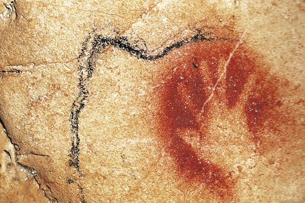
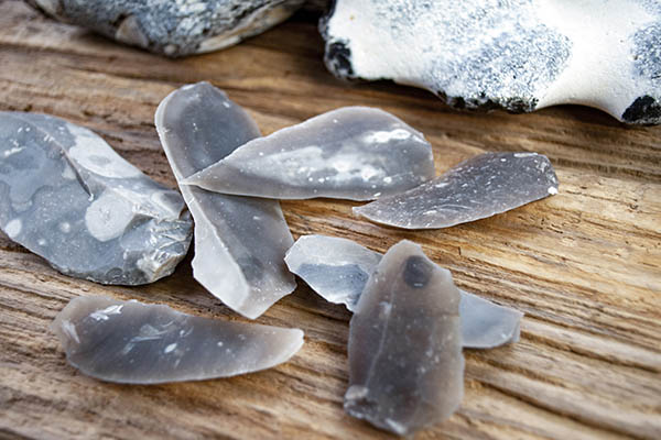
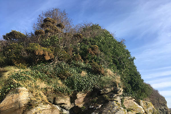
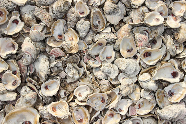
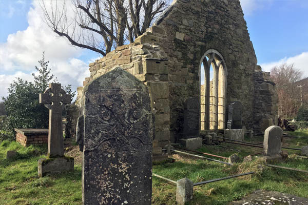
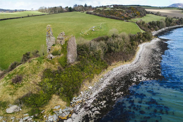
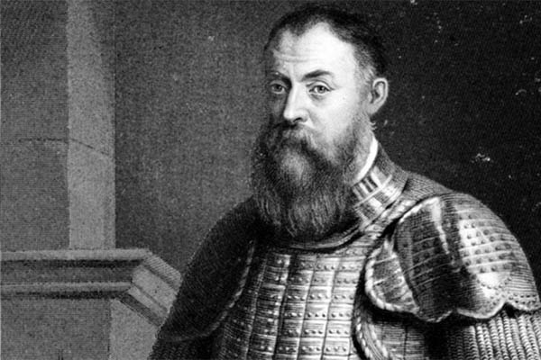
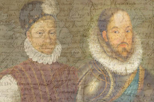
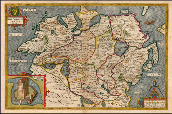
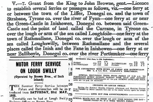
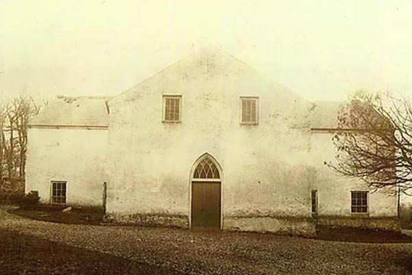
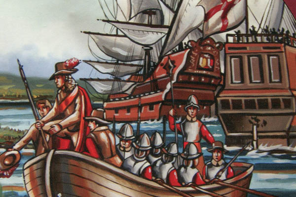
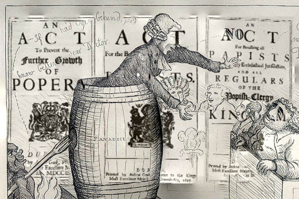
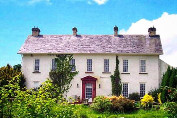
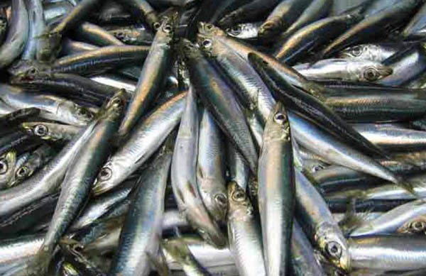
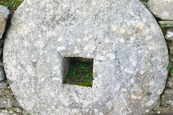
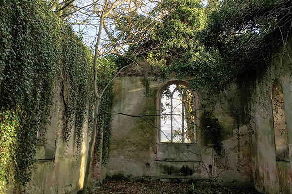
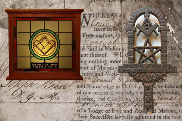
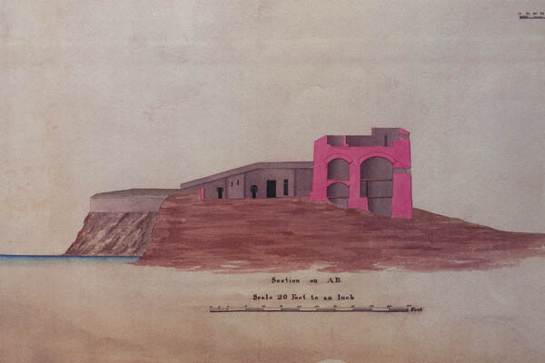
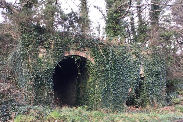

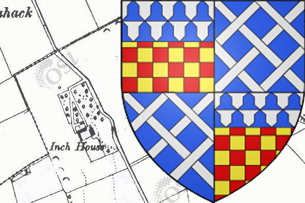
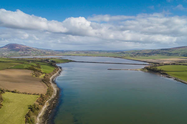
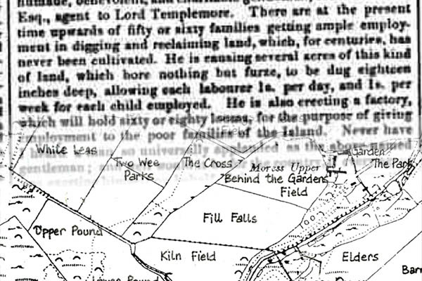
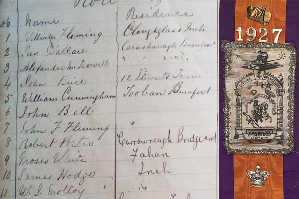
.jpg)